 DJI Mavic 4 Pro Creator Combo (512GB)
 DJI Mavic 4 Pro Fly More Combo
 DJI Mavic 4 Pro
 DJI Care Refresh 1-Year Plan (DJI Mavic 3 Pro)
 DJI Care Refresh 2-Year Plan (DJI Mavic 3 Pro)
 DJI Care Refresh 1-Year Plan (DJI Mavic 3 Pro Cine)
 DJI Care Refresh 2-Year Plan (DJI Mavic 3 Pro Cine)
 DJI Mavic 3 Series 100W Battery Charging Hub
 DJI Mavic 3 Series Intelligent Flight Battery
 DJI Mavic 3 Classic Storage Cover
 DJI Power SDC to DJI Mavic 3 Series Fast Charge Cable
 DJI Mavic 3
  DJI Mavic 3 Fly More Combo
  DJI Mavic 3 Cine Premium Combo (Open Box)
 Mavic 2 Pro (Drone Only, No Battery)
 Mavic 2 Zoom (Drone Only)
 Ex-Demo Mavic 2 Zoom
 Mavic 2 Pro
 SunnyLife Low-Noise Propellers for Mavic Pro (2 Pairs)
 CrystalSky Mavic/Spark Remote Controller Mounting Bracket
 D1 Aircraft Sleeve
 Mavic Pro Fly More Combo
 DJI Air 3S
 DJI Air 3S Fly More Combo w. DJI RC-N3
 DJI Air 3S Fly More Combo w. DJI RC 2
 DJI Air 3 Fly More Combo w. DJI RC 2
 DJI Air 3 Fly More Combo
 DJI Air 2S Fly More Combo
 DJI Mini Shoulder Bag
 GPC Safety Case V2 for Mavic Air 2
 Mavic Air 2 Battery to Power Bank Adaptor
 DJI RC-N Series Remote Controller Monitor Hood
 Mavic Air (Arctic White)
 DJI Mini 5 Pro Fly More Combo
 DJI Mini 5 Pro Fly More Combo Plus
 DJI Mini 5 Pro
 DJI Mini 5 Pro Fly More Combo w. DJI RC-N3
 DJI Mini 4 Pro Fly More Combo (Refurbished)
 DJI Mini 4 Pro Fly More Combo Plus (Refurbished)
 DJI Care Refresh 1-Year Plan (DJI Mini 3)
 DJI Care Refresh 2-Year Plan (DJI Mini 3)
 DJI RC
 DJI Mini 4 Pro/Mini 3 Series Two-Way Charging Hub
 DJI Care Refresh 1-Year Plan (DJI Mini 2 SE & DJI Mini 4K)
 DJI Care Refresh 2-Year Plan (DJI Mini 2 SE & DJI Mini 4K)
 PGYTECH Lens Hood for DJI Mini Series
 DJI Mini 2 / SE Intelligent Flight Battery
 DJI Mini 3 Pro w. DJI RC
  DJI Mini 3 Pro (Drone Only, No Battery)
 PGYTECH Control Stick Protector for Mavic Mini
 Mavic - RC Cable (Reverse Micro USB connector)
 Mavic - RC Cable (Standard Micro USB connector)
 Mavic Mini Remote Controller (open box)
 DJI Lito X1 Fly More Combo
 DJI Lito X1 Fly More Combo Plus
 DJI Lito X1
 DJI Lito X1 Fly More Combo (DJI RC-N3)
 DJI Lito 1
 DJI Lito 1 Fly More Combo
 DJI Flip
 DJI Flip w. DJI RC 2
 DJI Flip Fly More Combo
 Freewell All Day Filters for DJI Flip/Lito X1 (12 Pack)
 DJI Care Refresh 1-Year Plan (DJI Flip)
 DJI Care Refresh 2-Year Plan (DJI Flip)
 DJI RC 2
 D1 Labs 100W Braided USB-C Cable
 D1 Labs Lunar Glow USB-C Cable
 DJI RC/RC 2 Control Sticks
 D1 Labs Screen Protector for DJI RC Series
 D1 Labs Monitor Hood for DJI RC-N Series
 D1 Labs Heavy Duty Lanyard
 D1 Labs Lanyard Kit for DJI RC-N Series
 D1 Labs USB-C Wrist Strap Cable
 DJI Neo 2 (Drone Only)
 DJI Neo 2 Fly More Combo (Drone Only)
 DJI Neo 2 Fly More Combo
 DJI Neo 2 Motion Fly More Combo
 DJI Neo
 DJI Neo Fly More Combo
 Ex-Demo DJI Neo
 Ex-Demo DJI Neo Fly More Combo
 DJI Avata 360 Fly More Combo
 DJI Avata 360 Motion Fly More Combo
 DJI Avata 360 (Drone Only)
 DJI Avata 360 w. DJI RC 2
 DJI Avata 2 Fly Smart Combo
 DJI Avata 2 Fly Smart Combo (Three Batteries)
 DJI Avata 2 Fly More Combo
 DJI Avata 2 Fly More Combo (Three Batteries)
 DJI FPV Goggles V2 Motion Combo
 DJI Goggles 3
 DJI Goggles N3
 DJI O4 Air Unit
 DJI O4 Air Unit Pro
 DJI O4 Wide Air Unit
 DJI Avata (Drone Only, No Battery)
 DJI Avata Intelligent Flight Battery
 DJI Avata Propeller Guard
 SunnyLife Propeller Guard Protector for DJI Avata
 DJI O3 Air Unit
 DJI FPV Remote Controller 3
 DJI O3 Air Unit 3-in-1 Cable
 DJI FPV Combo
  Osmo Pocket 4 Standard Combo
 Osmo Pocket 4 Creator Combo
 Osmo Action 6 Standard Combo
 Osmo Action 6 Adventure Combo
 DJI Mic Mini 2 Dual Microphone Combo
 DJI Mic Mini 2 Single Microphone Kit
  DJI Mic Mini 2 Dual Microphone Combo (Mobile)
 DJI Mic Mini 2 Single Microphone Kit (Mobile)
 Osmo Nano Standard Combo (64GB)
 Osmo Nano Standard Combo (128GB)
 Osmo 360 Standard Combo
 Osmo 360 Adventure Combo
 Osmo Mobile 8P Standard Combo
 Osmo Mobile 8P Advanced Tracking Combo
 Osmo Mobile 8P Creator Combo
 Osmo Mobile 8 Advanced Tracking Combo
 Osmo Pocket 3 Standard Combo
 Osmo Pocket 3 Creator Combo
 Osmo Pocket 3 (Refurbished)
 Osmo Pocket 3 Creator Combo (Refurbished)
 Osmo Action 5 Pro Standard Combo
 Osmo Action 5 Pro Adventure Combo
 DJI Mic 3 Dual Microphone Combo
 DJI Mic 3 Single Microphone Kit
 DJI Mic Mini Single Microphone Kit
 Osmo Action 4 Standard Combo
 Osmo Action 4 Adventure Combo
 DJI Mic 2 Single Microphone Kit
 DJI Mic 2 Transmitter (Pearl White)
 DJI Care Refresh 2-Year Plan (DJI Pocket 2)
 Osmo Pocket 3.5mm Adapter
 DJI Care Refresh 1-Year Plan (Osmo Action 3)
 DJI Care Refresh 2-Year Plan (Osmo Action 3)
 Osmo Action Carrying Bag
 Osmo Action 60m Waterproof Case
 DJI Action 2 Dual Screen Combo
 DJI Osmo Action
  Osmo Pocket
 DJI RS 5
 DJI RS 5 Combo
 DJI RS 4 Pro Combo (2026)
 DJI RS 4 Mini
 DJI RS 4 Mini Combo
 DJI RS 4
 DJI RS 3 Mini
 DJI RS 3
 DJI RS 3 Pro
 DJI RS 2
 DJI RS 2 Pro Combo
 DJI RSC 2
 DJI RSC 2 Pro Combo
 Ronin-S
 Ronin-SC
 Ronin 4D-6K
 Ronin 4D-8K
 DJI Inspire 3 Basic Package
 DJI Inspire 3
 DJI Focus Pro Creator Combo
 DJI Focus Pro All-In-One Combo
 DJI Transmission (High-Bright Monitor Combo)
 DJI Transmission (Standard Combo)
 DJI Video Transmitter
 DJI Video Receiver
 DJI SDR Transmission Combo
 DJI SDR Transmission Receiver
 DJI SDR Transmission Transmitter
 Inspire 2
 Ex-Demo Inspire 2
 DJI Power 1000 Mini
 DJI Power 2000
 DJI Power 1000 V2
 DJI Power 1000 Portable Power Station
 DJI Power Expansion Battery 2000
 DJI Power 1000 Protective Storage Bag
 DJI Power Dongle
 IBCPOWER 100W Foldable Solar Panel
 DJI Power Series Hand Truck
 DJI Power MC4 to XT60 Solar Power Cable
 DJI Power SDC to DJI Inspire 3 Fast Charge Cable
 DJI Power SDC to Car Charger Plug Power Cable (12V)
 Zignes 120W Solar Panel
 DJI Power Solar Panel Adapter Module (MPPT)
 DJI ROMO S (Water Tank Version)
 DJI ROMO P (Water Tank Version)
 DJI ROMO A (Water Tank Version)
 ROMO Accessory Kit
 ROMO Cleaning Solution
 ROMO Side Brush
 ROMO Mop Pad
 Matrice 30T Dock Bundle
 NextCore RN50 Drone LiDAR
 Cendence-S Remote Controller For M200 V2 Series
 Zenmuse H30
 Zenmuse H30T
 ParaZero SafeAir Parachute for Matrice 30 Series
 ParaZero SafeAir Parachute for DJI Mavic 3 Series (ASTM Compliant)
 DJI Dock 2
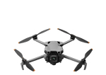
 DJI Matrice 4E
 DJI Matrice 4T
 DJI Matrice 4D
 DJI Matrice 4D Combo
 DJI Matrice 4TD
 DJI Matrice 4TD Combo
 DJI Matrice 400
 DJI Dock 3
 DJI Mavic 3 Thermal Advanced
 DJI Mavic 3 Multispectral
 DJI FlyCart 30
 DJI FlyCart 100
 Zenmuse L2
 Zenmuse P1
 Phase One P3 Payload (iXM 120MP) with 80mm AF
 Deepthink S2 Pro Night Vision Payload
 Mavic 2 Enterprise Advanced
 Matrice 30T
 Matrice 300 RTK
  Deepthink S2 Night Vision Payload for Matrice 300 Series
 Zenmuse H20T
  DJI Care Enterprise Plus (DJI Matrice 400)
 DJI Care Enterprise Plus (DJI Matrice 4E)
 DJI Maintenance Program Basic Service (Matrice 300 RTK)
 DJI Maintenance Program Standard Service (Mavic 2 Series)
 DJI Maintenance Program Standard Service (Matrice 300 RTK)
 DJI AGRAS T100
 DJI AGRAS T70P
 AGRAS T50
 DJI RC Plus for AGRAS Series
 DJI AGRAS T25P
 AGRAS T25
 Ex-Demo AGRAS T40 (Drone Only, No Batteries)
 DJI AGRAS T30 (Excluding Batteries)
 X2D II 100C
 907X & CFV 100C
 XCD 45P
 XCD 2,5/25V
 XCD 2,5/38V
 XCD 2,5/55V
 UGREEN 65W Nexode S GaN Charger
 Freewell Pro Card Reader (CF A/B, SD, TF)
 LiPO Battery Safe Bag (Medium)
 D1 Labs Landing Pad Pro (50CM)
 Lexar Professional 256GB Silver Plus MicroSD Card
 D1 Labs High-Speed SD Card Reader
 DJI Care Refresh 1-Year Plan (DJI Mini 5 Pro)
 DJI Care Refresh 2-Year Plan (DJI Mini 5 Pro)
 D1 Labs Safety Case for DJI Mini 5 Pro
 DJI Mini 5 Pro Shoulder Bag
 DJI Care Refresh 1-Year Plan (DJI Neo)
 DJI Care Refresh 2-Year Plan (DJI Neo)
 DJI RC-N3 Remote Controller
 Osmo Pocket 4 Handle with 1/4" Thread
 Freewell Must Have Filters for Osmo Pocket 3/4 (3 Pack)
 DJI Care Refresh 1-Year Plan (Osmo Pocket 3)
 DJI Care Refresh 2-Year Plan (Osmo Pocket 3)
 DJI Care Refresh 1-Year Plan (Osmo Mobile 7P)
 DJI OM 7 Series Tracking Kit
 Osmo 1.6m Tripod Selfie Stick
 DJI OM Magnetic Phone Clamp 5
 DJI Care Refresh 1-Year Plan (Osmo Mobile 7)
 DJI OM 7 Series Magnetic Phone Clamp
 DJI Care Refresh 1-Year Plan (DJI RS 4 Mini)
 DJI Care Refresh 2-Year Plan (DJI RS 4 Mini)
 DJI RS Enhanced Intelligent Tracking Module
 DJI RS Intelligent Tracking Module
 DJI Care Refresh 1-Year Plan (DJI Mini 4 Pro)
 DJI Care Refresh 2-Year Plan (DJI Mini 4 Pro)
 DJI Care Refresh 1-Year Plan (DJI Air 3S)
 DJI Care Refresh 2-Year Plan (DJI Air 3S)
 DJI RC Pro 2
 DJI Care Refresh 1-Year Plan (DJI RS 4)
 DJI Care Refresh 2-Year Plan (DJI RS 4)
 DJI Care Refresh 1-Year Plan (Osmo Action 5 Pro)
 DJI Care Refresh 2-Year Plan (Osmo Action 5 Pro)
 D1 Labs Screen & Lens Protector for Osmo Action 5 Pro
 DJI Care Refresh 1-Year Plan (DJI Mavic 4 Pro)
 DJI Care Refresh 2-Year Plan (DJI Mavic 4 Pro)
 PGYTECH OneGo Air Backpack 25L | Obsidian Black
 D1 Labs Safety Case for DJI Mavic 4 Pro
 DJI Care Refresh 1-Year Plan (DJI RS 4 Pro)
 DJI Care Refresh 2-Year Plan (DJI RS 4 Pro)
 DJI Care Refresh 1-Year Plan (Osmo Action 4)
 DJI Care Refresh 2-Year Plan (Osmo Action 4)
 D1 Labs Camera Cage for Osmo Action 3/4/5 Pro
 DJI Mic 3 Receiver
 DJI Mic 3 Transmitter
 DJI Mic 3 Charging Case
 DJI Mic Series Mobile Receiver
 DJI Mic Series Carrying Pouch
 DJI Mic Mini Windscreen (Black & Grey w. Black Clip)
 DJI Mic Mini Multi-Color Windscreens
 Osmo Locking Screw
 DJI Care Refresh 1-Year Plan (Osmo Nano)
 DJI Care Refresh 2-Year Plan (Osmo Nano)
 D1 Labs Screen & Lens Protector for Osmo Nano
 DJI Care Refresh 1-Year Plan (Osmo 360)
 DJI Care Refresh 2-Year Plan (Osmo 360)
 Osmo 360 Carrying Bag
 UGREEN 145W 25000mAh Power Bank
 UGREEN FineTrack Smart Finder
 UGREEN 130W USB-C Car Charger
 D1 Labs Landing Pad Pro (65CM)
 D1 Labs Landing Pad Pro (100CM)
 D1 Labs Weighted Drone Landing Pad (92 cm)
 D1 Labs Screen Protector for DJI RC Pro
 SunnyLife Carrying Case for DJI RC Pro
  SunnyLife Protective Cover for DJI RC Pro
 D1 Labs Drone Safety Sign
 D1 Labs Retractable Safety Cone (450 mm)
 LiPO Battery Safe Bag (Large)
 Freewell Standard Day Filters for Osmo Nano (4 Pack)
 Freewell Everyday Filters for DJI Neo 2 (3 Pack)
 Freewell Galaxy Series Snow Mist 1/4 Filter
 Freewell Sherpa Series Case for iPhone 13 Pro
 Freewell Sherpa Series Case for iPhone 13 Pro Max
 Phantom 4 Pro V2.0 Remote Controller
  DJI RC Motion 3
 Cynova Protective Cover for DJI RC Pro 2
 D1 Labs Screen Protector for DJI RC Pro 2
 D1 Labs Lanyard Bracket for DJI RC Pro 2
 D1 Labs Dual Hook Controller Lanyard
 DJI Care Refresh 1-Year Plan (DJI Avata 2)
 DJI Care Refresh 1-Year Plan (DJI Neo 2)
 DJI Care Refresh 2-Year Plan (DJI RS 5)
 DJI Care Refresh 2-Year Plan (DJI Avata 2)
 DJI Care Refresh 2-Year Plan (DJI Avata 360)
 DJI Care Enterprise Basic (D-RTK 3 Multifunctional Station)
 DJI Care Enterprise Basic (DJI Mavic 3 Enterprise)
 DJI Care Enterprise Basic (Zenmuse S1)
 DJI Care Enterprise Basic (Zenmuse V1)
 DJI Care Enterprise Basic 2-Year Plan (D-RTK 3 Multifunctional Station)
 DJI Care Enterprise Basic 2-Year Plan (Zenmuse S1)
 DJI Care Enterprise Basic 2-Year Plan (Zenmuse V1)
 DJI Care Enterprise Basic 2-Year Plan (Zenmuse L2)
 DJI Care Enterprise Plus (Zenmuse P1)
 DJI Care Enterprise Plus (DJI Matrice 4T)
 Ex-Demo DJI Mini 3 (DJI RC-N1)
 Ex-Demo Osmo Pocket 3 Creator Combo
 Ex-Demo DJI Neo 2 Fly More Combo (Drone Only)
 Ex-Demo DJI Neo 2 (Drone Only)
 Freewell CPL Filter for DJI Mavic 3 Pro
 Freewell Standard Day Filters for DJI Neo (3 Pack)
 Freewell Bright Day Filters for DJI Neo (3 Pack)
 CrystalSky Monitor Hood (For 7.85 Inch)
 Ex-Demo Osmo 360 Standard Combo
 Ex-Demo DJI Mic 3 Dual Microphone Combo
 Ex-Demo DJI Mic 3 Single Microphone Kit
 Ex-Demo Osmo Mobile 8 Advanced Tracking Combo
 Ex-Demo WB37 Intelligent Battery
 Ex-Demo DJI Mic 3 Transmitter
 Ex-Demo DJI Neo Intelligent Flight Battery
 Ex-Demo DJI Goggles 3
 Ex-Demo Mavic 2 Enterprise Zoom
 Ex-Demo DJI Matrice 4D
  Ex-Demo DJI Matrice 4D Combo
 Ex-Demo Matrice 200 TB55 Intelligent Flight Battery
 Ex-Demo DJI DL-S 16mm F2.8 ND ASPH Lens
 Ex-Demo TB60 Intelligent Flight Battery
 Ex-Demo ChengZhi FL48 Lighting System
 Ex-Demo Zenmuse P1
 Ex-Demo Zenmuse X5S
 Ex-Demo Zenmuse X7
 Ex-Demo Wingsland Z15 Gimbal Spotlight
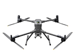


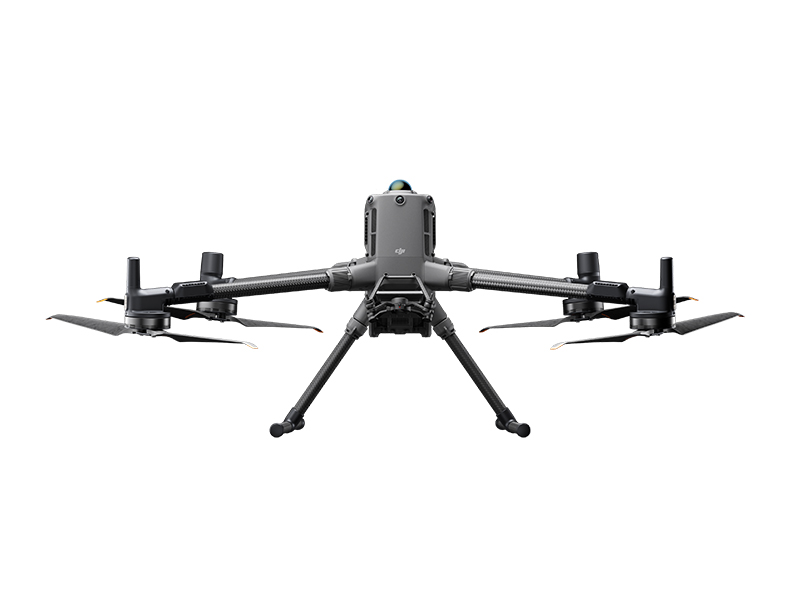
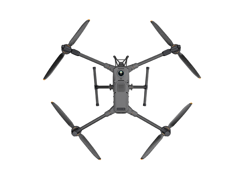
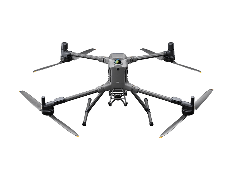
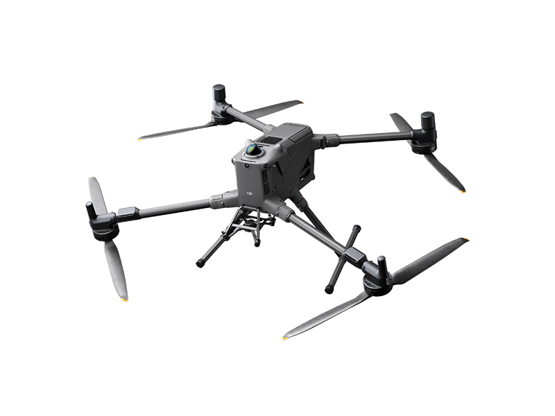
Engineered for Excellence, Designed for Versatility
Built to Go the Distance
Designed for demanding missions, the Matrice 400 offers up to 59 minutes of flight time with a payload and can hover for up to 53 minutes , making it well-suited for extended tasks like emergency response, wildfire monitoring, and extensive surveying and mapping tasks.
Its advanced obstacle avoidance system allows it to navigate around large structures such as buildings and mountains even when flying at speeds up to 25 m/s, enabling safer, high-speed operations in complex environments.
Complete Aerial Versatility
With a flexible payload platform and 6kg maximum carrying capacity, the DJI Matrice 400 is designed for ultimate operational versatility.
Capable of seamless switching between a single downward gimbal and dual downward gimbal, it also features a third gimbal connection on the underside of the aircraft’s body. This in addition to 4 external E-port V2 ports, means the Matrice 400 can simultaneously mount up to 7 payloads, accommodating whatever your mission requires.

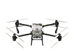
Zenmuse H30 Series
The Zenmuse H30 Series integrates five major modules—a wide-angle camera, a zoom camera, an infrared thermal camera, a laser range finder, and an NIR auxiliary light. Employing cutting-edge intelligent algorithms, it revolutionizes perception and imaging standards, transcending the limitations of day and night vision.

Zenmuse L2
Zenmuse L2 integrates frame-based LiDAR, a self-developed high-accuracy IMU system, and a 4/3 CMOS RGB mapping camera, providing DJI multi-payload drone platform with more precise, efficient, and reliable geospatial data acquisition.

Zenmuse P1
Zenmuse P1 integrates a full-frame sensor with interchangeable fixed-focus lenses on a 3-axis stabilized gimbal. Designed for photogrammetry flight missions, it takes efficiency and accuracy to a whole new level.

Zenmuse S1
Zenmuse S1 is DJI's first spotlight designed for multi-payload drone platforms. Utilizing the LEP technology, it offers high brightness and long illumination distance, and supports multiple lighting modes. This makes it ideal for public safety, emergency rescue, inspection, and other nighttime operations.

Zenmuse V1
Zenmuse V1 is DJI's first loudspeaker designed for multi-payload drone platforms. It boasts high volume and long broadcast distance, and supports multiple broadcast modes, making it ideal for scenarios like public safety, emergency rescue, and more.

Manifold 3
Manifold 3 packs an impressive 100 TOPS of computing power into a compact unit weighing about 120 g. It can be mounted onto Matrice 400 drone platform, optimizing efficiency across various operational missions with its robust processing.
Breaking Boundaries
Estimate the Matrice 400’s flight time based on payload configuration.

Confidence in All Conditions
Boasting an Ingress Protection Rating of IP55, rain and dust is no match for the Matrice 400. And continuing to reliably operate across temperatures ranging from -20°C to 50°C it is configured to perform in even the toughest of environments.
The Matrice 400 is equipped with a next-generation obstacle avoidance system that combines rotating LiDAR, precision mmWave radar, and full-colour low-light fisheye vision sensors.
This multi-sensor arsenal enables it to detect even fine obstacles like high-voltage power lines in complex environments such as mountainous terrain, including at night. Capable of seeing through rain and fog, the system ensures reliable situational awareness and safety, even in adverse weather.

Robust Transmission
O4 Enterprise
The O4 Enterprise Enhanced Video Transmission System delivers transmission ranges of up to 40 km, made possible by a ten-antenna setup on the drone and a high-gain phased array antenna on the remote controller.
Additionally, the Matrice 400 is compatible with the sub-2GHz frequency band, and when outfitted with dual DJI Cellular Dongle 2 units, it can seamlessly switch between carrier networks. This ensures more reliable connectivity, whether operating in dense urban areas with signal interference or in isolated, remote locations.
Airborne Relay
The Matrice 400 features an integrated video transmission relay module, allowing one unit to act as a high-altitude relay for another drone operating farther away.
This setup effectively extends transmission range, making it especially valuable for long-distance missions such as search and rescue operations or inspections in rugged, mountainous terrain.
Aircraft Fusion Positioning
With advanced omnidirectional sensing powered by rotating LiDAR, high-precision mmWave radar, and full-colour low-light fisheye sensors, the Matrice 400 delivers exceptional positioning accuracy.
It can maintain stable flight near reflective surfaces like glass buildings or wind turbine blades, and confidently navigate back from complex environments, such as mountain slopes, bridges, or high-rise structures.

Intelligent Insights, Seamless Operation
Smart Detection
When equipped with the Zenmuse H30 Series’ thermal and visible imaging, the Matrice 400 can identify vehicles, vessels, and individuals during both emergency missions and routine operations.
It also offers flexibility with support for interchangeable payloads, allowing users to adapt to different mission requirements. Advanced features like high-resolution grid photography and precise subject tracking further enhance its situational awareness and operational versatility.
Smart AR Projection
Real-Time Terrain Follow
With Real-Time Terrain Follow in all horizontal directions, supporting both manual control and automated flight paths, the aircraft maintains a stable altitude relative to the ground at all times.
In large-area search and rescue missions, it helps keep the size of ground subjects consistent on the controller screen, minimising the need for constant zooming. For mapping tasks, it maintains a uniform ground sampling distance (GSD), resulting in high-accuracy data collection.
Maritime Vessel Take-off & Landing
Designed to accommodate offshore missions such as wind turbine inspection and maritime patrol, Matrice 400 is capable of landing on moving vessels by identifying landing point patterns on deck.
Enterprise Ready

Public Safety

Power Line Inspection

Geographic Information

Oil and Natural Gas

Renewable Energy

Water Conservation

Maritime

Roads and Bridges
Precision at Your Fingertips
Pilot Matrice 400 with the DJI RC Plus 2 Enterprise Enhanced remote controller, designed specifically to cater to the demands of Enterprise users.
Sporting a large, high-bright display, powerful internal processors and IP54 protection, DJI RC Plus 2 Enterprise Enhanced is built to deliver stable and smooth transmission in all environments.

Comprehensive Protection
Straight out of the boxEnjoy added peace of mind with one year of DJI Care Enterprise Plus coverage with DJI Matrice 400.
Care Enterprise Plus unlocks comprehensive product protection with unlimited free repairs within the coverage limit and up to one Flyaway claim during the coverage period.


* Always check and strictly abide by local laws and regulations before flying.
** All data on this page was collected with a production model of DJI Matrice 400 in a controlled test environment. Actual experience may vary depending on the environment, usage, and firmware version.
*** All videos and photos on this page were shot in strict compliance with local laws and regulations. Demos, including wildlife, were shot from a safe distance and are used for reference only. Please observe local laws and regulations and ensure the aircraft has obtained relevant certifications before flying.
**** Before use, Matrice 400 must be activated via the DJI Pilot 2 app.